

Suzanne Cole uses a low brace to stay upright in Tweedle Dum Falls. Ron Chase photos
The White Mountains in New Hampshire have more to offer than great hiking, climbing and skiing. In the spring, melting snow drains into the steep streams and rivers flowing out of the tall peaks. For a few weeks in late April and May, they provide some of the best whitewater paddling in New England.
Over the years, Chowderheads with the Penobscot Paddle & Chowder Society have avidly pursued the many paddling options the White Mountains furnish. The East Branch of the Pemigewasset in Lincoln and the Swift River near Conway are two of our favorites. The Peabody, Ellis, Rocky Branch and East Branch of the Saco are less frequented because they rarely have sufficient water. All have a commonality; they are rocky descents with steeper gradients than most Maine rivers.
Another popular New Hampshire spring freshet is the Upper Saco. Headwater of the substantial Saco River that progresses to the ocean in Maine, the Upper begins in Crawford Notch and tumbles downhill to the town of Bartlett. Barring heavy rains, the Upper is only available for a short period each spring, usually in May. Prospective paddlers look for a flow in the range of 650–1,500 cubic feet per second on the U.S. Geological Survey gauge in Bartlett. Lower levels are impassable and higher volumes can be downright scary.
Kevin McKenzie kayaks one of many rapids on the Upper Saco.
After studying water levels, club member Craig McKinnon announced an Upper Saco trip in May. Although snow accumulations were less than normal in the Whites this past winter, Craig identified a day when the flow was sufficient for an exhilarating adventure.
Nine Chowderheads met at a small parking area next to a bridge over the Saco on the River Road in Bartlett on a cloudy, cool day. Our paddling entourage consisted of six kayaks and two canoes. All participants were in solo boats except Ryan Galway and his teenage daughter, Krea, who paddled a tandem canoe. Sufficient vehicles were left at the takeout for the return shuttle and we drove north on Route 302 for about 5 miles to the Mount Nancy Trailhead.
We elected to avoid the usual put-in farther north near Davis Path because a long portage around a difficult gorge is normally necessary. Instead, we carried and hauled our boats through the woods to the river. In retrospect, the portage is probably easier as our choice turned out to be more arduous than anticipated and required lowering boats down a steep embankment.
We enthusiastically launched in the steep, narrow, boulder-strewn stream. From the outset, choosing the best routes through the rocky labyrinths was challenging. Carefully watching for fallen trees and other debris in the almost continuous whitewater was a necessity. Situated higher in his canoe than the kayakers, Craig probed a majority of the rapids.
The first rapid was indicative of what was to follow. From the top, it was almost impossible to determine the proper passage. We eddy hopped as far downriver as practicable before identifying a narrow, diagonal, rock-infested channel through a precipitous boulder pile. Everyone nailed it.
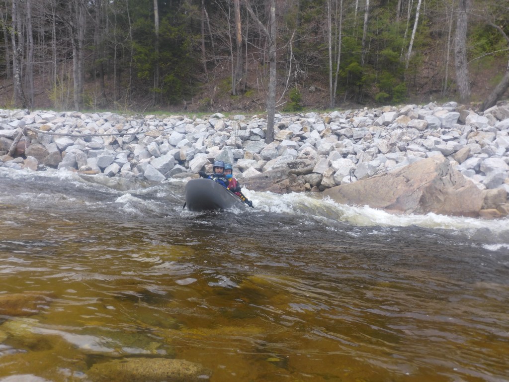
Canoeists Krea and Ryan Galway complete a rapid on the Upper Saco.
More exacting descents ensued. Our determined band replicated the successful technique as we plummeted through one rocky falls after another.
Those of us who were veterans of previous Upper Saco adventures were guardedly watching for two more difficult falls comically called Tweedle Dee and Tweedle Dum. Arriving at the finish of a long rapid where the Sawyer River enters on the right, we were close.
Tweedle Dee is a twisting descent that requires navigating between several huge boulders and around some intimidating holes at the end. Our crew handled it flawlessly.
The approach to Tweedle Dum is deceptive. From upstream, it appears quite benign. We boat scouted and eddy hopped to the top of an abrupt right turn. A rocky prominence on the right obscures a clear view until the last moment. Nine capable Chowderheads plunged through a circuitous passage while avoiding potentially boat-flipping holes and several threatening boulders.
The gradient moderates below. However, it remained a busy stimulating river. After angling southeasterly, the river widens. Route-finding was more complex and the threat of dangerous debris obstructing the river greater. Our intrepid group was up to the task, and we completed a truly outstanding White Mountain whitewater adventure.
My book, “Maine Al Fresco: The Fifty Finest Outdoor Adventures in Maine,” narrates many more exciting whitewater exploits around Maine.
Ron Chase resides in Topsham. His latest book, “Maine Al Fresco: The Fifty Finest Outdoor Adventures in Maine” is available at northcountrypress.com/maine-al-fresco or in bookstores and through online retailers. His previous books are “The Great Mars Hill Bank Robbery” and “Mountains for Mortals – New England.” Visit his website at ronchaseoutdoors.com or he can be reached at ronchaseoutdoors@comcast.net.
Send questions/comments to the editors.


Comments are no longer available on this story